Discover Cromford – Cromford Village Walk
Walk One – A Walk around the Village
This walk will take up to an hour. Allow extra time if you take option 3.
Turn left to the Market Place. To your right you will see the Greyhound Hotel. This imposing inn was built in 1778 by Arkwright for businessmen and his many visitors. It incorporated a bank; its windows and door can be seen on the left side of the building. The original clock is still there. In 1790 Arkwright obtained a charter for a Saturday market (closed 1880). The houses next to the Greyhound were originally shops, and the row of single story shops on the right were market stalls, known as the Shambles. Before the advent of the railways, this would have been a hive of activity. Coaches, such as the Defiance and the Lord Nelson set off daily to London, Birmingham, Sheffield, Nottingham and Manchester. Carriers operated services several days a week to London and various towns in Derbyshire.
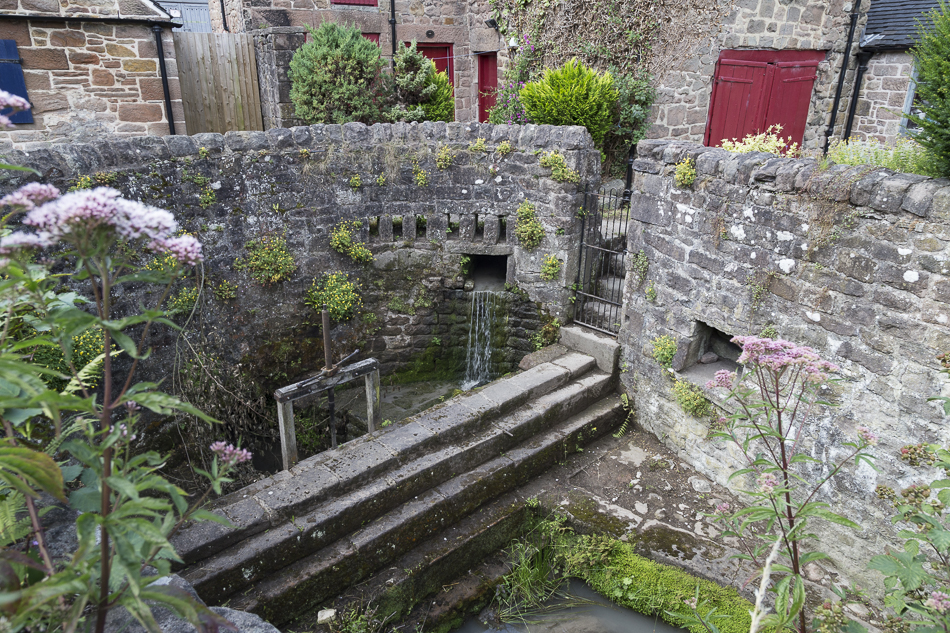
Cross the road, walk right past the Arkwright Stores, one of a row of six houses, built by Richard Arkwright as part of his factory village in the 1780s and converted for retail use in the 19th century. The two bowed shop windows are a rare survival from the early 19th century. Originally it had a slate roof. Take the entry to the left. A short way along the path can be seen the walled culvert constructed by Richard Arkwright in 1785 to control the flow of the Cromford Sough to the cotton mills by means of gates and wooden stop boards. This stone pit was sunk into the Sough, which drained water from the lead mines. It is comprised of a dam which held the water and forced it into an underground channel to the millpond behind the Greyhound and a sluice, which controlled water to be supplied directly to the Mill. It could also act as a drain from the pond. Water was redirected to the pond on Sundays in order to top it up in readiness for the new week ahead at Arkwright’s mill, which now had a second wheel. This surprising structure is known as the Bear Pit – bear baiting was all the rage in the 16th and 17th centuries and was not banned until 1835.
Beyond the Bear Pit are the remains of stone pig sties and troughs. Opposite is a yard where a square of cobbles can be seen. Here animals were slaughtered. The old village lock-up, which has two small cells where offenders were held, is at the opposite corner of the yard. It is the middle part of a building which predates the Arkwright period, and was originally three cottages. The middle cottage became the lock-up after 1790, when the Quarter Sessions, or local courts, required that each community should provide a secure place for alleged felons to be held until they could be transferred to Derby. This contains two small cells with metal doors. One cell retains its original bunk, which is suspended from the walls by a chain. Arkwright imprisoned anyone thieving from his Mill.
Return to the path and continue between allotments and more pig sties. On the right is the old pinfold, used as a holding field for cattle awaiting slaughter. The backs of the houses on North Street can be seen, note the blocked up windows of the top storeys which were used by framework knitters and weavers. The path comes out opposite the rear of the school. Built in 1832, together with a schoolmaster’s house, by Richard Arkwright junior, it had provision for 200 boys and girls who were housed in separate buildings along the sides of a square court. Later enlarged and altered, it is now a Church of England primary school with about 180 pupils.
Turn right, and you enter the bottom end of North Street. These houses were built between 1776-7 by Arkwright to house his mill workers. It is the first planned industrial housing in Derbyshire with two rows of gritstone 3-storied houses, each originally consisting of a living room, bedroom and interconnecting weaving rooms in the attic. Bathrooms and kitchens were added later at the rear. The attic rooms had windows at the back and front to give good light for the outworkers at their frames. The windows at the back of the houses have since been blocked off. Number 10 belongs to the Landmark Trust which has restored the house inside and the rear attic window.
The railings at the front of the school were replaced in 2002 after being removed in WW2 to help the war effort. You will see a trough to the right of the school railings. This was the original water supply for the entire street, being fed by Longhead sough. Follow the path winding between the back of the North Street houses and the raised gardens. Down here you will see a barn, pre-dating Arkwright, inside were the old cattle stalls. The building has been converted into a house. The path emerges on Cromford Hill. Turn left and a short way on turn left again into Bedehouse Lane. The path veers to the right and then goes straight uphill, following the backs of houses. Views open out on the left across the fields to Ferny Rocks. Look back to see the Arkwright family’s mansion, Willersley Castle in the distance.
Continue uphill to the Almshouses. These were founded in 1662 in accordance with the will of Mary Talbot, the Lady Armine, who left money and land for bede houses for six poor and elderly widows and widowers. A weathered stone coat-of-arms can be seen on the side of the building, which is still in occupation. The path passes some pretty stone cottages, before emerging onto Barnwell Lane.
There are 3 options here:
Option 1. On Barnwell Lane turn right. The road comes out on Cromford Hill. The house on the left at the junction, by the bus stop was once the Red Lion Public House. Carefully cross the busy road and follow the pavements back down to the Market Place. There are Arkwright houses lining the opposite side of the road, these are later than those in North Street. Further down adjoining Alabaster Lane are several pre-Arkwright late 17th and early 18th century houses. Below North Street, several houses of Victoria Terrace (built 1839) have the traditional wet wash finish and some the original window frames.
Option 2. Cross Barnwell Lane and follow the steep signposted path. Look to the right to see the large working Dene Quarry. The path emerges onto Baker’s Lane. Turn right here and as you walk look at the views over Cromford. The tall red chimney of Masson Mill, Willersley Castle and Ball Eye Quarry can all be seen in the distance, with Riber Castle on the skyline. To the left are the Black Rocks. You come out onto Cromford Hill. Turn right to return to the Market Place as in option 1.
Option 3. On Barnwell Lane turn left. This is a rather longer walk back to the village over fields. Round the corner and up a bit there is a track on the left which leads past a farmhouse. No longer a working farm, the barns and cattle sheds are now mostly converted. Continue past Spring Cottage and through a stile into a field. There are good views of Scarthin to the left. You now go through another stile into a second field, passing a tumbledown stone barn. Views of the village open out and you can see Dene Quarry and Chapel Hill. To the right the ground rises steeply to a rock outcrop called Ferny Rocks. If you climb up the field and keep to the right of Ferny Rocks you will find a path which lead through woodland to Intake Lane and so back to Cromford, or go higher to join the High Peak Trail. Continue into the next field. To the left can be seen Alison House, Willersley Castle and Rock House. You now enter the last field. The views to the left include Ball Eye Quarry, Cromford Court and the Heights of Abraham and Solomon’s Temple in Matlock Bath. The track emerges via a stile onto Intake Lane. To the right the road leads to the High Peak Trail and Cromford Canal or Black Rocks. Turn left downhill. The houses here were built mainly in the 1950s and 1960s to meet a demand for housing in the area when Derbyshire County Council headquarters moved from Derby to Matlock. There are some old houses on Intake Lane itself, namely Ashes Farm and a cluster of cottages. On reaching Derby Road (A6) turn left for a short walk back to the Market Place.