Landscape Character

Lower Derwent Valley Landscape Character
The Lower Derwent Valley area is located in Derbyshire within the Districts of Derbyshire Dales and the Amber Valley.
The Scheme area covers 71km² and is roughly the area that surrounds the Derwent Valley Mills World Heritage Site. Starting at the flood plains of Derby, at an elevation of 45m, and snaking 15 miles north along the River Derwent. The boundary finishes at the limestone gorges surrounding Matlock Bath and Cromford at an elevation 358m.
The Derwent Valley is an area globally recognised for its role in the Industrial Revolution and valued by visitors and by the local communities for its scenic landscape.
By geologists it is regarded as a ‘classic area’. The landscape is perceived to be highly natural and to have changed little since the 18th Century. However, many of the natural and cultural features which define its character have experienced considerable decline and continue to be under threat.
It is intended that the DerwentWISE will address many of these issues and contribute to halting this decline.
Physical and Natural Landscape
Woodland is the greatest land cover in the project area. The project area encompasses one of the largest broad leaved networks in the north of England. This concentration of woodland within the Derwent Valley is considered to be of national significance as it forms an interconnected corridor of habitat stretching up the Derwent Valley through the project area and beyond into the Peak District. The woodland occurs over two climatic zones and displays characteristics of both lowland and upland woods. There is great longevity to this resource, with an estimated 700ha of woodland classified as ancient woodland.
Ancient woodland in the UK, as in the tropics, is home to rare and threatened species: more than any other UK habitat, it is an irreplaceable resource.
In the north of the project area upland ash woods dominate the limestone slopes and dales of the Via Gellia and Matlock Bath gorges. These woodlands support a distinct array of wildlife including many nationally rare and scarce species. The gritstone woods further south also support a diverse flora reflecting the gradations between neutral and acid, and dry and damp woodland types.
After woodlands, the second most dominant habitat of landscape and biodiversity significance is semi-natural grassland. Species-rich meadows are an important resource for wildlife including bees, butterflies and mammals.
The DerwentWISE scheme area covers three distinct national landscape character areas: White Peak, Peak Fringe and Lower Derwent
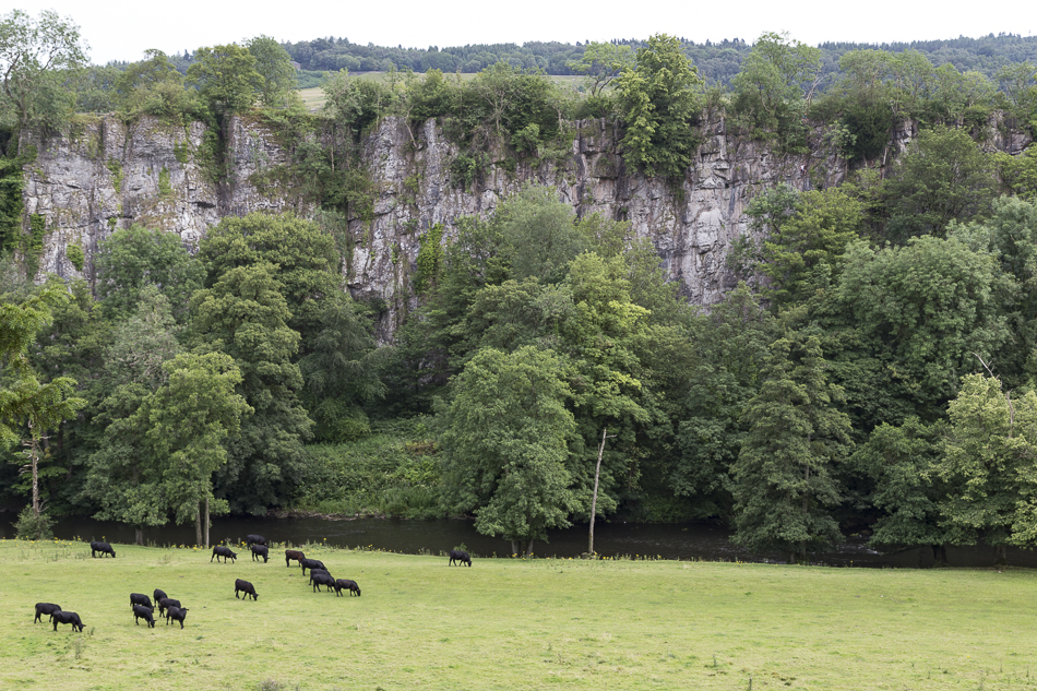
In the north, at Matlock Bath, you will find characteristics associated with the White Peak. Such as limestone plateau pastures, limestone hills & slopes, limestone village farmlands, and limestone dales.
Water courses meet at Cromford and proceed southward through the Millstone Grit. You’ll see steep valley sides to Ambergate that widen through Belper and onto Derby. The landscape here is dominated by wooded slopes, riverside meadows and areas of gritstone heaths. This is the landscape of the Derbyshire Peak Fringe and Lower Derwent.
The White Peak
“ …it was veined with a network of old stone walls, dividing the fields, and broken here and there with ruins of old lead-mines and works. A sparse stone farm bristled with six naked sharp trees. In the distance was a patch of smoky grey stone, a hamlet……stone fences under the sky, looking for the curves downward that indicated a drop to one of the underneath, hidden dales.”
DH Lawrence ‘The Virgin and the Gypsy
Geology
Geology is one of the fundamental shapers of the landscape we see today. The rocks of the Valley were formed many millions of years ago and are extremely influential on the landscape, plants, animals and people who live in the area.
There are two major geological formations within the project area. These are the limestone which underlies the White Peak and the gritstone of the Peak Fringe and Lower Derwent.
The limestone was formed between 360 and 326 million years ago during the Carboniferous Period. At this time the area was south of the equator and covered in tropical seas which were teaming with aquatic life. As the sea creatures died their calcium carbonate shells remained at the bottom of the sea and over a period of 30 million years, these turned into the limestone we see today. The grey limestone contributes considerably to the character of the landscape as it forms the principle stone used in the vernacular buildings and in the network of dry stone field walls that criss-cross the area.
Gritstone was also formed in the Carboniferous age when a huge river washed pebbles, sand and mud into the sea. The pebbles and coarser sand collected in the same areas and hardened to make coarse-grained, siliceous sandstone. Millstone Grit is the name given to a number of these sandstones found within the Penines, ranging from the Scottish Highlands to the edge of Breadsall and Little Eaton. Millstone Grit has been quarried for building stone, paving flags and roofing material. It is also used in the construction of dry stone walls across valley.
There are four geological Sites of Special Scientific Interest (SSSI) that occur within the area or immediately adjacent: Colehill Quarries, Ambergate and Ridgeway Quarries, Middle Peak Quarry and Masson Hill. In addition there are 32 Local Geological Sites (LGS) with potential for at least another five.
The diverse topography, geology and soil type have resulted in a varied mix of habitats and species throughout the DerwentWISE area. Much of the biodiversity interest is associated with woodlands and grasslands.

